
Javier topographic map
Interactive map
Click on the map to display elevation.
About this map
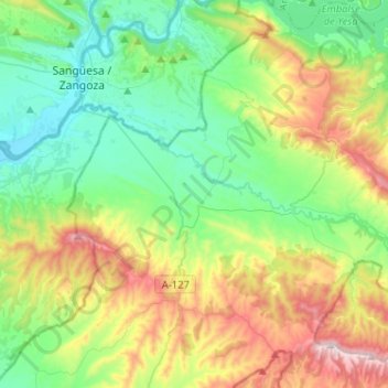
Name: Javier topographic map, elevation, terrain.
Location: Javier, Zangozerria / Comarca de Sangüesa, Spanje (42.42394 -1.34616 42.61304 -1.17548)
Average elevation: 2,044 ft
Minimum elevation: 1,263 ft
Maximum elevation: 3,766 ft
Other topographic maps
Click on a map to view its topography, its elevation and its terrain.
Yesa
Spanje > Zangozerria / Comarca de Sangüesa
Yesa, Zangozerria / Comarca de Sangüesa, Spanje
Average elevation: 2,264 ft
Lumbier
Spanje > Zangozerria / Comarca de Sangüesa
Lumbier, Zangozerria / Comarca de Sangüesa, 31440, Spanje
Average elevation: 1,939 ft