
Cayamatza topographic map
Interactive map
Click on the map to display elevation.
About this map
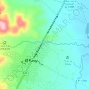
Name: Cayamatza topographic map, elevation, terrain.
Location: Cayamatza, El Pangui, Zamora Chinchipe, Ecuador (-3.62039 -78.59911 -3.61796 -78.56644)
Average elevation: 2,651 ft
Minimum elevation: 2,467 ft
Maximum elevation: 3,205 ft
Other topographic maps
Click on a map to view its topography, its elevation and its terrain.
El Oasis
Ecuador > Zamora Chinchipe > El Pangui > El Pangui
El Oasis, El Pangui, Zamora Chinchipe, Ecuador
Average elevation: 2,805 ft