
Make a donation
Gear up for your next adventure:
As an Amazon Associate, this site earns from qualifying purchases at no extra cost to you.
A Baña topographic map
Click on the map to display elevation.
Make a donation
Gear up for your next adventure:
As an Amazon Associate, this site earns from qualifying purchases at no extra cost to you.
A Baña
Vesía is a town situated near the centre of the A Baña municipality, in the A Coruña province. It is part of the parish of San Vicente, the capital of the municipality. Vesía is at an altitude of 317.6 meters above sea level, and stands at an incline of 20.89%. Vesía has a population of around 40 people, the majority of whom are between 65 and 80 years old as the area has suffered youth emigration.
Make a donation
Gear up for your next adventure:
As an Amazon Associate, this site earns from qualifying purchases at no extra cost to you.
About this map
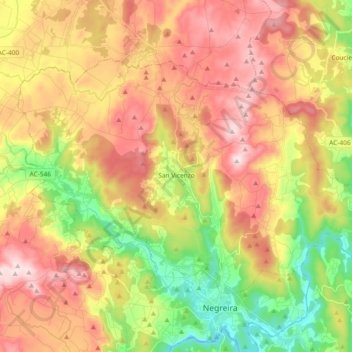
Name: A Baña topographic map, elevation, terrain.
Location: A Baña, A Barcala, A Coruña, Galicia, 15863, Spain (42.91627 -8.84152 43.00686 -8.65624)
Average elevation: 1,066 ft
Minimum elevation: 420 ft
Maximum elevation: 1,693 ft
Make a donation
Gear up for your next adventure:
As an Amazon Associate, this site earns from qualifying purchases at no extra cost to you.
Other topographic maps
Click on a map to view its topography, its elevation and its terrain.