
Eugenie Glacier topographic map
Interactive map
Click on the map to display elevation.
About this map
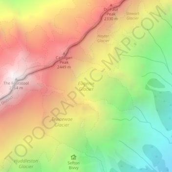
Name: Eugenie Glacier topographic map, elevation, terrain.
Average elevation: 5,994 ft
Minimum elevation: 2,900 ft
Maximum elevation: 8,944 ft
Other topographic maps
Click on a map to view its topography, its elevation and its terrain.
Mount Cook Village
New Zealand > Canterbury > Mount Cook Village
Mount Cook Village, Mackenzie District, Canterbury, 7946, New Zealand
Average elevation: 3,228 ft
Red Tarns
New Zealand > Canterbury > Mount Cook Village
Red Tarns, Red Tarns Track, Mount Cook Village, Mackenzie District, Canterbury, 7946, New Zealand
Average elevation: 3,271 ft
Mueller Glacier
New Zealand > Canterbury > Mount Cook Village
Mueller Glacier, Mueller Hut Route, Mount Cook Village, Mackenzie District, Canterbury, 7946, New Zealand
Average elevation: 5,302 ft