
Make a donation
Gear up for your next adventure:
As an Amazon Associate, this site earns from qualifying purchases at no extra cost to you.
Kandahar topographic map
Click on the map to display elevation.
Make a donation
Gear up for your next adventure:
As an Amazon Associate, this site earns from qualifying purchases at no extra cost to you.
Kandahar
Kandahar (English: /ˈkændəhɑːr/; Pashto: کندهار Kandahār, Dari: قندهار, Qandahār) is a city in Afghanistan, located in the south of the country on the Arghandab River, at an elevation of 1,010 m (3,310 ft). It is Afghanistan's second largest city after Kabul, with a population of about 614,118. It is the capital of Kandahar Province as well as the de facto capital of the Taliban, formally known as the Islamic Emirate of Afghanistan. It also happens to be the centre of the larger cultural region called Loy Kandahar. In 1709, Mirwais Hotak made the region an independent kingdom and turned Kandahar into the capital of the Hotak dynasty. In 1747, Ahmad Shah Durrani, founder of the Durrani dynasty, made Kandahar the capital of the Afghan Empire. Historically this province is considered as important political area for Afghanistan revelations.
Make a donation
Gear up for your next adventure:
As an Amazon Associate, this site earns from qualifying purchases at no extra cost to you.
About this map
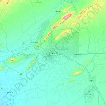
Name: Kandahar topographic map, elevation, terrain.
Location: Kandahar, Kandahar Province, 3801, Afghanistan (31.46057 65.55576 31.78057 65.87576)
Average elevation: 3,438 ft
Minimum elevation: 3,084 ft
Maximum elevation: 5,827 ft
Make a donation
Gear up for your next adventure:
As an Amazon Associate, this site earns from qualifying purchases at no extra cost to you.