Geolocate

衡南县 topographic map

Interactive map

Click on the map to display elevation.

About this map

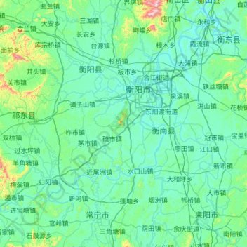
Name: 衡南县 topographic map, elevation, terrain.

Location: 衡南县, 衡阳市, 湖南省, 421115, 中国 (26.54728 112.10928 26.98347 113.14984)

Average elevation: 420 ft

Minimum elevation: 135 ft

Maximum elevation: 3,717 ft

Other topographic maps

Click on a map to view its topography, its elevation and its terrain.

荆坪村

中国 > 湖南省 > 衡阳市

荆坪村, 衡阳市, 湖南省, 中国

Average elevation: 413 ft

关市镇

中国 > 湖南省 > 衡阳市

关市镇, 衡阳市, 湖南省, 中国

Average elevation: 784 ft

营盘山

中国 > 湖南省 > 衡阳市

营盘山, 衡阳市, 湖南省, 中国

Average elevation: 226 ft

刘家院

中国 > 湖南省 > 衡阳市

刘家院, 衡阳市, 湖南省, 中国

Average elevation: 489 ft

东湖圩镇

中国 > 湖南省 > 衡阳市

东湖圩镇, 衡阳市, 湖南省, 中国

Average elevation: 817 ft

茶山坳镇

中国 > 湖南省 > 衡阳市

茶山坳镇, 衡阳市, 湖南省, 中国

Average elevation: 236 ft

南岳镇

中国 > 湖南省 > 衡阳市

南岳镇, 南岳区, 衡阳市, 湖南省, 中国

Average elevation: 1,102 ft

衡阳县

中国 > 湖南省 > 衡阳市

衡阳县, 衡阳市, 湖南省, 中国

Average elevation: 587 ft

衡山县

中国 > 湖南省 > 衡阳市

衡山县, 衡阳市, 湖南省, 421341, 中国

Average elevation: 492 ft

南岳区

中国 > 湖南省 > 衡阳市

南岳区, 衡阳市, 湖南省, 中国

Average elevation: 1,099 ft

珠晖区

中国 > 湖南省 > 衡阳市

珠晖区, 衡阳市, 湖南省, 中国

Average elevation: 253 ft

蒸湘区

中国 > 湖南省 > 衡阳市

蒸湘区, 衡阳市, 湖南省, 中国

Average elevation: 243 ft

衡东县

中国 > 湖南省 > 衡阳市

衡东县, 衡阳市, 湖南省, 中国

Average elevation: 469 ft