
Aïn Sebt topographic map
Interactive map
Click on the map to display elevation.
About this map
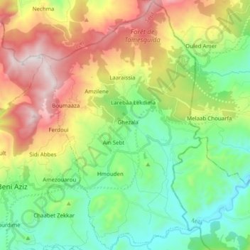
Name: Aïn Sebt topographic map, elevation, terrain.
Location: Aïn Sebt, Daïra Beni Aziz, Sétif, 19033, Algérie (36.43295 5.66750 36.55656 5.76515)
Average elevation: 2,933 ft
Minimum elevation: 1,467 ft
Maximum elevation: 5,489 ft
Other topographic maps
Click on a map to view its topography, its elevation and its terrain.
Beni Aziz
Algérie > Sétif > Daïra Beni Aziz
Beni Aziz, Daïra Beni Aziz, Sétif, Algérie
Average elevation: 2,894 ft