
Radazul topographic map
Interactive map
Click on the map to display elevation.
About this map
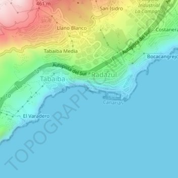
Name: Radazul topographic map, elevation, terrain.
Average elevation: 335 ft
Minimum elevation: -3 ft
Maximum elevation: 1,506 ft
Other topographic maps
Click on a map to view its topography, its elevation and its terrain.
La Esperanza
La Esperanza, El Rosario, Santa Cruz de Ténérife, Îles Canaries, 38290, Espagne
Average elevation: 2,848 ft