
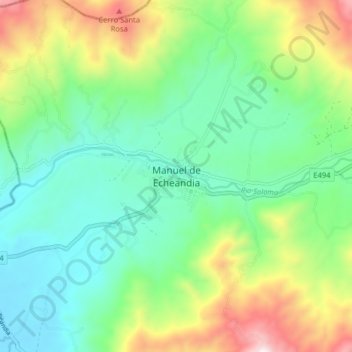
Manuel de Echeandia topographic map
Interactive map
Click on the map to display elevation.
About this map
Name: Manuel de Echeandia topographic map, elevation, terrain.
Location: Manuel de Echeandia, Echeandía, Bolívar, Ecuador (-1.47199 -79.31974 -1.39199 -79.23974)
Average elevation: 1,594 ft
Minimum elevation: 610 ft
Maximum elevation: 3,789 ft
Other topographic maps
Click on a map to view its topography, its elevation and its terrain.
Recinto "San Vicente"
Ecuador > Bolívar > Echeandía > Manuel de Echeandia
Recinto "San Vicente", Manuel de Echeandia, Echeandía, Bolívar, 020401, Ecuador
Average elevation: 1,283 ft
Recinto Santa Lucía
Recinto Santa Lucía, Echeandía, Bolívar, Ecuador
Average elevation: 2,858 ft
Recinto El Tesoro
Ecuador > Bolívar > Echeandía > Manuel de Echeandia > Recinto El Tesoro
Recinto El Tesoro, Manuel de Echeandia, Echeandía, Bolívar, Ecuador
Average elevation: 1,388 ft