
Pontrhydfendigaid topographic map
Interactive map
Click on the map to display elevation.
About this map
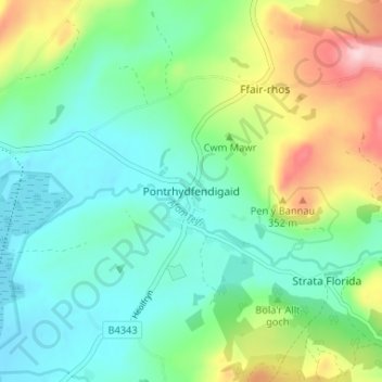
Name: Pontrhydfendigaid topographic map, elevation, terrain.
Location: Pontrhydfendigaid, Ceredigion, Wales, SY25 6BB, United Kingdom (52.26458 -3.88224 52.30458 -3.84224)
Average elevation: 748 ft
Minimum elevation: 528 ft
Maximum elevation: 1,283 ft