
Make a donation
Gear up for your next adventure:
As an Amazon Associate, this site earns from qualifying purchases at no extra cost to you.
Lubango topographic map
Click on the map to display elevation.
Make a donation
Gear up for your next adventure:
As an Amazon Associate, this site earns from qualifying purchases at no extra cost to you.
Lubango
In 1882 approximately one thousand Portuguese settlers came from the island of Madeira to the area of current-day Lubango. These Portuguese farmers helped develop the region and founded the settlement. The city, originally established in 1885 to serve colonists from the Madeira Islands, lies at an elevation of 1,760 metres in a valley of the Huíla Plateau and was surrounded by a scenic park spreading up the mountain slopes.
Make a donation
Gear up for your next adventure:
As an Amazon Associate, this site earns from qualifying purchases at no extra cost to you.
About this map
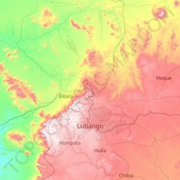
Name: Lubango topographic map, elevation, terrain.
Location: Lubango, Huíla Province, Angola (-15.12663 13.35834 -14.32771 14.35567)
Average elevation: 4,012 ft
Minimum elevation: 1,250 ft
Maximum elevation: 7,772 ft
Make a donation
Gear up for your next adventure:
As an Amazon Associate, this site earns from qualifying purchases at no extra cost to you.
Other topographic maps
Click on a map to view its topography, its elevation and its terrain.