
Make a donation
Gear up for your next adventure:
As an Amazon Associate, this site earns from qualifying purchases at no extra cost to you.
West Lafayette topographic map
Click on the map to display elevation.
Make a donation
Gear up for your next adventure:
As an Amazon Associate, this site earns from qualifying purchases at no extra cost to you.
West Lafayette
West Lafayette, located in Tippecanoe County, Indiana, presents a varied topography, particularly shaped by its proximity to the Wabash River. The city spans an elevation range from approximately 500 feet near the river to over 720 feet in its northern sections, offering a noticeable incline toward higher ground. The river itself borders the city to the east and south, providing a valley-like feature that influences the surrounding landscape. Northern areas, near U.S. Route 52, are situated on more elevated terrain. This diverse elevation contributes to a mix of flat river plains and rolling hills, offering both scenic views and practical land use for residential and university spaces.
Make a donation
Gear up for your next adventure:
As an Amazon Associate, this site earns from qualifying purchases at no extra cost to you.
About this map
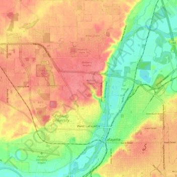
Name: West Lafayette topographic map, elevation, terrain.
Location: West Lafayette, Tippecanoe County, Indiana, United States (40.40002 -86.96244 40.48954 -86.88698)
Average elevation: 630 ft
Minimum elevation: 492 ft
Maximum elevation: 738 ft
Tippecanoe County trails, hiking, mountain biking, running and outdoor activities
Make a donation
Gear up for your next adventure:
As an Amazon Associate, this site earns from qualifying purchases at no extra cost to you.
Other topographic maps
Click on a map to view its topography, its elevation and its terrain.
Happy Hollow Heights
United States > Indiana > Tippecanoe County > West Lafayette > Happy Hollow Heights
Average elevation: 620 ft