
Peel Forest topographic map
Interactive map
Click on the map to display elevation.
About this map
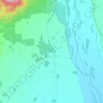
Name: Peel Forest topographic map, elevation, terrain.
Location: Peel Forest, Timaru District, Canterbury, New Zealand (-43.93122 171.24038 -43.89122 171.28038)
Average elevation: 935 ft
Minimum elevation: 725 ft
Maximum elevation: 2,080 ft
Other topographic maps
Click on a map to view its topography, its elevation and its terrain.
Timaru
New Zealand > Canterbury > Timaru District
Timaru, Timaru District, Canterbury, 7910, New Zealand
Average elevation: 52 ft
Woodbury
New Zealand > Canterbury > Timaru District
Woodbury, Timaru District, Canterbury, New Zealand
Average elevation: 663 ft
Geraldine
New Zealand > Canterbury > Timaru District
Geraldine, Timaru District, Canterbury, 7930, New Zealand
Average elevation: 427 ft
Temuka
New Zealand > Canterbury > Timaru District > Temuka
Temuka, Timaru District, Canterbury, 7920, New Zealand
Average elevation: 79 ft
Pleasant Point
New Zealand > Canterbury > Timaru District
Pleasant Point, Timaru District, Canterbury, 7903, New Zealand
Average elevation: 279 ft