
Mount Gilead topographic map
Interactive map
Click on the map to display elevation.
About this map
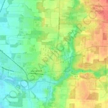
Name: Mount Gilead topographic map, elevation, terrain.
Average elevation: 1,135 ft
Minimum elevation: 1,050 ft
Maximum elevation: 1,237 ft
Mount Gilead is located at 40°33′8″N 82°49′54″W / 40.55222°N 82.83167°W / 40.55222; -82.83167 (40.552090, -82.831587).[12] Its elevation is 1,081 feet above sea level.
Other topographic maps
Click on a map to view its topography, its elevation and its terrain.
Westfield
United States > Ohio > Morrow County
Westfield, Westfield Township, Morrow County, Ohio, 43003, United States
Average elevation: 968 ft
Russell
United States > Ohio > Morrow County
Russell, Gilead Township, Morrow County, Ohio, 43315, United States
Average elevation: 1,119 ft
Cardington
United States > Ohio > Morrow County
Cardington, Cardington Township, Morrow County, Ohio, United States
Average elevation: 1,017 ft
Marengo
United States > Ohio > Morrow County
Marengo, Bennington Township, Morrow County, Ohio, United States
Average elevation: 1,132 ft