
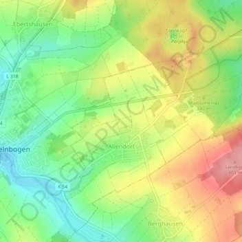
Allendorf topographic map
Interactive map
Click on the map to display elevation.
About this map
Name: Allendorf topographic map, elevation, terrain.
Average elevation: 1,096 ft
Minimum elevation: 928 ft
Maximum elevation: 1,293 ft
Other topographic maps
Click on a map to view its topography, its elevation and its terrain.
Obernhof
Allemagne > Rhénanie-Palatinat > Rhein-Lahn-Kreis > Obernhof
Obernhof, Bad Ems-Nassau, Rhein-Lahn-Kreis, Rhénanie-Palatinat, Allemagne
Average elevation: 699 ft
Siedlung Loreley
Allemagne > Rhénanie-Palatinat > Rhein-Lahn-Kreis > Bornich
Siedlung Loreley, Bornich, Loreley, Rhein-Lahn-Kreis, Rhénanie-Palatinat, 56329, Allemagne
Average elevation: 725 ft
Birlenbach
Allemagne > Rhénanie-Palatinat > Rhein-Lahn-Kreis
Birlenbach, Diez, Rhein-Lahn-Kreis, Rhénanie-Palatinat, 65626, Allemagne
Average elevation: 646 ft
Wellmich
Allemagne > Rhénanie-Palatinat > Rhein-Lahn-Kreis > Sankt Goarshausen > Wellmich
Wellmich, Sankt Goarshausen, Loreley, Rhein-Lahn-Kreis, Rhénanie-Palatinat, Allemagne
Average elevation: 738 ft
Sankt Goarshausen
Allemagne > Rhénanie-Palatinat > Rhein-Lahn-Kreis
Sankt Goarshausen, Loreley, Rhein-Lahn-Kreis, Rhénanie-Palatinat, Allemagne
Average elevation: 814 ft