
Gœttingue topographic map
Interactive map
Click on the map to display elevation.
About this map
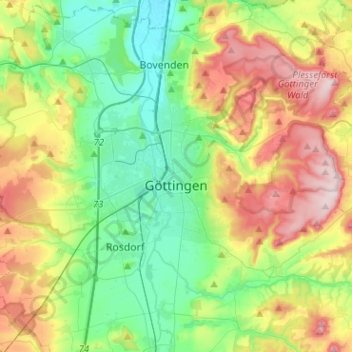
Name: Gœttingue topographic map, elevation, terrain.
Location: Gœttingue, Göttingen (arrondissement), Basse-Saxe, Allemagne (51.48301 9.80013 51.59082 10.05360)
Average elevation: 784 ft
Minimum elevation: 420 ft
Maximum elevation: 1,434 ft
Other topographic maps
Click on a map to view its topography, its elevation and its terrain.
Duderstadt
Allemagne > Basse-Saxe > Göttingen (arrondissement)
Duderstadt, Göttingen (arrondissement), Basse-Saxe, 37115, Allemagne
Average elevation: 781 ft
Harz (Landkreis Göttingen)
Allemagne > Basse-Saxe > Göttingen (arrondissement)
Harz (Landkreis Göttingen), Göttingen (arrondissement), Basse-Saxe, 37445, Allemagne
Average elevation: 1,486 ft