Geolocate

Jessheim topographic map

Click on the map to display elevation.

About this map
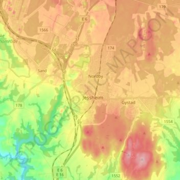
Name: Jessheim topographic map, elevation, terrain.

Location: Jessheim, Ullensaker, Viken, 2066, Norway (60.10151 11.13515 60.18151 11.21515)

Average elevation: 627 ft

Minimum elevation: 358 ft

Maximum elevation: 866 ft

Other topographic maps

Click on a map to view its topography, its elevation and its terrain.

Aremark

Norway > Viken

Average elevation: 492 ft

Indre Østfold

Norway > Viken

Average elevation: 486 ft

Rollag

Norway > Viken

Average elevation: 2,139 ft

Nordre Follo

Norway > Viken

Average elevation: 466 ft

Hemsedal

Norway > Viken

Average elevation: 3,993 ft

Fødalen landskapsvernområde

Norway > Viken

Average elevation: 4,865 ft

Gear up for your next adventure:

🥤Water Filter Bottle - All‑in‑one filter bottle for safe hydration
🥩Freeze-Dried Meals - Nutritious and lightweight food for remote expeditions
👓Polarized Sunglasses - Outdoor sunglasses for glare reduction
⌚Solar GPS Watches - Advanced multisport watches with built-in topographic maps
📡GPS Antenna Upgrade - Enhance GPS reception in remote terrain

As an Amazon Associate, this site earns from qualifying purchases at no extra cost to you.