
Levittown topographic map
Click on the map to display elevation.
About this map
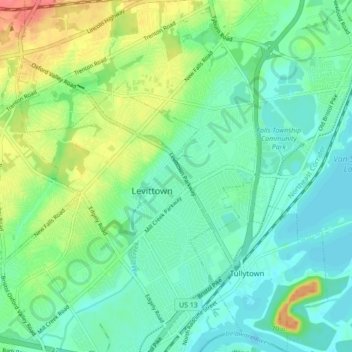
Name: Levittown topographic map, elevation, terrain.
Average elevation: 59 ft
Minimum elevation: 0 ft
Maximum elevation: 187 ft
Bucks County trails, hiking, mountain biking, running and outdoor activities
Other topographic maps
Click on a map to view its topography, its elevation and its terrain.
Farmbrook
United States > Pennsylvania > Bucks County > Bristol Township > Levittown
Average elevation: 43 ft
Blue Ridge
United States > Pennsylvania > Bucks County > Bristol Township > Levittown
Average elevation: 52 ft
Blue Ridge
United States > Pennsylvania > Bucks County > Bristol Township > Levittown
Average elevation: 52 ft
Red Cedar Hill
United States > Pennsylvania > Bucks County > Bristol Township > Levittown > Red Cedar Hill
Average elevation: 69 ft