
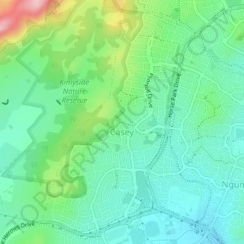
Casey topographic map
Interactive map
Click on the map to display elevation.
About this map
Name: Casey topographic map, elevation, terrain.
Average elevation: 2,165 ft
Minimum elevation: 1,988 ft
Maximum elevation: 2,625 ft
Until 1990, Casey was part of the former 'Gold Creek' a 3,940-acre (15.9 km2) rural property with the Gold Creek Homestead at its centre. The relative flat and even topography of portions of the suburb of Casey was ideal for various pursuits including horse racing, and was the site of a practice track for racing horses. A stand of trees parallel to Horse Park Drive which predates the establishment of the village (now the suburb) of Hall marks the original alignment of the Queanbeyan-Yass Road.
Other topographic maps
Click on a map to view its topography, its elevation and its terrain.
Taylor
Australia > District of Gungahlin
Taylor, District of Gungahlin, Australian Capital Territory, Australia
Average elevation: 2,274 ft
Gubur Dhaura
Australia > District of Gungahlin
Gubur Dhaura, Franklin, District of Gungahlin, Australian Capital Territory, 2913, Australia
Average elevation: 2,041 ft
Bonner
Australia > District of Gungahlin
Bonner, District of Gungahlin, Australian Capital Territory, Australia
Average elevation: 2,149 ft
Throsby
Australia > District of Gungahlin
Throsby, District of Gungahlin, Australian Capital Territory, Australia
Average elevation: 2,073 ft
Ngunnawal
Australia > District of Gungahlin
Ngunnawal, District of Gungahlin, Australian Capital Territory, 2913, Australia
Average elevation: 2,070 ft
Nicholls
Australia > Australian Capital Territory > District of Gungahlin
Nicholls, District of Gungahlin, Australian Capital Territory, Australia
Average elevation: 2,041 ft
Crace
Australia > District of Gungahlin
Crace, District of Gungahlin, Australian Capital Territory, 2911, Australia
Average elevation: 2,014 ft
Forde
Australia > District of Gungahlin
Forde, District of Gungahlin, Australian Capital Territory, Australia
Average elevation: 2,096 ft
Amaroo
Australia > District of Gungahlin
Amaroo, District of Gungahlin, Australian Capital Territory, Australia
Average elevation: 2,064 ft
Palmerston
Australia > District of Gungahlin
Palmerston, District of Gungahlin, Australian Capital Territory, Australia
Average elevation: 2,018 ft
Harrison
Australia > District of Gungahlin
Harrison, District of Gungahlin, Australian Capital Territory, Australia
Average elevation: 2,034 ft
Franklin
Australia > District of Gungahlin
Franklin, District of Gungahlin, Australian Capital Territory, Australia
Average elevation: 2,021 ft
Moncrieff
Australia > District of Gungahlin
Moncrieff, District of Gungahlin, Australian Capital Territory, Australia
Average elevation: 2,113 ft