
Plancherine topographic map
Interactive map
Click on the map to display elevation.
About this map
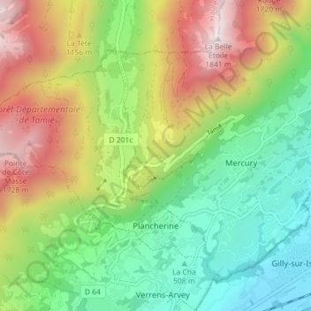
Name: Plancherine topographic map, elevation, terrain.
Average elevation: 2,917 ft
Minimum elevation: 1,047 ft
Maximum elevation: 5,915 ft
Other topographic maps
Click on a map to view its topography, its elevation and its terrain.
Mallapalud
France > Auvergne-Rhône-Alpes > Plancherine > Mallapalud
Mallapalud, Plancherine, Albertville, Savoie, Auvergne-Rhône-Alpes, France métropolitaine, 73200, France
Average elevation: 3,097 ft