
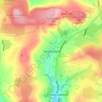
Loveclough topographic map
Interactive map
Click on the map to display elevation.
About this map
Name: Loveclough topographic map, elevation, terrain.
Average elevation: 1,030 ft
Minimum elevation: 673 ft
Maximum elevation: 1,339 ft
Other topographic maps
Click on a map to view its topography, its elevation and its terrain.
Haslingden Grane
United Kingdom > England > Lancashire > Borough of Rossendale > Haslingden
Haslingden Grane, Haslingden, Borough of Rossendale, Lancashire, England, BB4 4AU, United Kingdom
Average elevation: 942 ft
Fold Head
United Kingdom > England > Lancashire > Borough of Rossendale > Healey
Fold Head, Whitworth, Healey, Borough of Rossendale, Lancashire, England, OL12 8XL, United Kingdom
Average elevation: 965 ft
Whitewell Bottom
United Kingdom > England > Lancashire > Borough of Rossendale > Sagar Holme
Whitewell Bottom, Sagar Holme, Borough of Rossendale, Lancashire, England, BB4 9DE, United Kingdom
Average elevation: 922 ft
Ewood Bridge
United Kingdom > England > Lancashire > Borough of Rossendale
Ewood Bridge, Borough of Rossendale, Lancashire, England, BB4 6LZ, United Kingdom
Average elevation: 741 ft
Clowbridge
United Kingdom > England > Lancashire > Borough of Rossendale > Habergham Eaves
Clowbridge, Habergham Eaves, Borough of Rossendale, Lancashire, England, United Kingdom
Average elevation: 1,047 ft
Irwell Springs
United Kingdom > England > Lancashire > Borough of Rossendale > Weir
Irwell Springs, Weir, Borough of Rossendale, Lancashire, England, OL13 8QX, United Kingdom
Average elevation: 1,198 ft
Whitworth
United Kingdom > England > Lancashire > Borough of Rossendale
Whitworth, Borough of Rossendale, Lancashire, England, United Kingdom
Average elevation: 1,040 ft
Rising Bridge
United Kingdom > England > Lancashire > Borough of Rossendale
Rising Bridge, Borough of Rossendale, Lancashire, England, BB5 2RY, United Kingdom
Average elevation: 922 ft
Stacksteads
United Kingdom > England > Lancashire > Borough of Rossendale
Stacksteads, Borough of Rossendale, Lancashire, England, OL13 0SG, United Kingdom
Average elevation: 1,004 ft
Rawtenstall
United Kingdom > England > Lancashire > Borough of Rossendale
Rawtenstall, Borough of Rossendale, Lancashire, England, BB4 7NE, United Kingdom
Average elevation: 932 ft
Stubbins
United Kingdom > England > Lancashire > Borough of Rossendale > Stubbins
Stubbins, Borough of Rossendale, Lancashire, North West England, England, BL0 0NN, United Kingdom
Average elevation: 764 ft
Edenfield
United Kingdom > England > Lancashire > Borough of Rossendale
Edenfield, Borough of Rossendale, Lancashire, England, BL0 0LB, United Kingdom
Average elevation: 774 ft