Geolocate

Corning topographic map

Click on the map to display elevation.

About this map

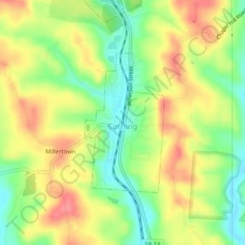
Name: Corning topographic map, elevation, terrain.

Location: Corning, Perry County, Ohio, United States (39.59524 -82.09365 39.61060 -82.08228)

Average elevation: 833 ft

Minimum elevation: 712 ft

Maximum elevation: 948 ft

Perry County trails, hiking, mountain biking, running and outdoor activities

Other topographic maps

Click on a map to view its topography, its elevation and its terrain.

Straitsville

United States > Ohio > Perry County

Average elevation: 876 ft

Jonathan Creek

United States > Ohio > Perry County > Glenford

Average elevation: 948 ft

Mount Perry

United States > Ohio > Perry County

Average elevation: 896 ft

Gear up for your next adventure:

🪓Survival Multi‑Tool - Versatile tool for camp and trail tasks
💧Water Purification System - Clean water on the trail with reliable purifiers
🚗GPS Dash Cams - Record your scenic drives through mountain passes and canyons
🎒Hydration Pack - Hands‑free water reservoir for long hikes
☀️Outdoor Sunscreen - High protection sunscreen for outdoor activities

As an Amazon Associate, this site earns from qualifying purchases at no extra cost to you.