
Thun topographic map
Interactive map
Click on the map to display elevation.
About this map
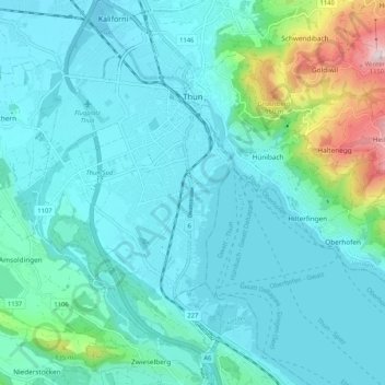
Name: Thun topographic map, elevation, terrain.
Average elevation: 2,090 ft
Minimum elevation: 1,788 ft
Maximum elevation: 3,734 ft
Other topographic maps
Click on a map to view its topography, its elevation and its terrain.
Goldiwil
Switzerland > Bern > Thun administrative district > Thun
Goldiwil, Thun, Horrenbach-Buchen, Thun administrative district, Oberland administrative region, Bern, 3624, Switzerland
Average elevation: 2,799 ft