
Sima Punta de las Olas topographic map
Interactive map
Click on the map to display elevation.
About this map
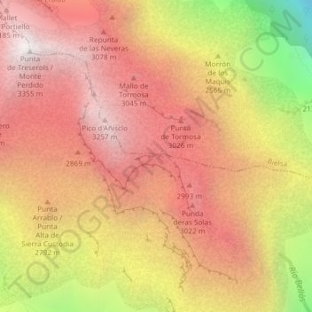
Name: Sima Punta de las Olas topographic map, elevation, terrain.
Average elevation: 8,730 ft
Minimum elevation: 4,888 ft
Maximum elevation: 10,961 ft
Other topographic maps
Click on a map to view its topography, its elevation and its terrain.
Pic du Taillon
Espagne > Aragon > Sobrarbe > Fanlo
Pic du Taillon, Fanlo, Sobrarbe, Aragon, Espagne
Average elevation: 8,474 ft
Pyrénées - Mont Perdu
Espagne > Aragon > Sobrarbe > Fanlo
Pyrénées - Mont Perdu, Fanlo, Sobrarbe, Huesca, Aragon, Espagne
Average elevation: 8,360 ft
Refuge de Goriz
Espagne > Aragon > Sobrarbe > Fanlo
Refuge de Goriz, Camino Brecha Rolando, Fanlo, Sobrarbe, Huesca, Aragon, 22375, Espagne
Average elevation: 7,815 ft