
Make a donation
Gear up for your next adventure:
As an Amazon Associate, this site earns from qualifying purchases at no extra cost to you.
Town of Portland topographic map
Click on the map to display elevation.
Make a donation
Gear up for your next adventure:
As an Amazon Associate, this site earns from qualifying purchases at no extra cost to you.
About this map
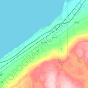
Name: Town of Portland topographic map, elevation, terrain.
Location: Town of Portland, Chautauqua County, New York, United States (42.29881 -79.52814 42.45414 -79.41134)
Average elevation: 902 ft
Minimum elevation: 558 ft
Maximum elevation: 1,709 ft
Chautauqua County trails, hiking, mountain biking, running and outdoor activities
Make a donation
Gear up for your next adventure:
As an Amazon Associate, this site earns from qualifying purchases at no extra cost to you.
Other topographic maps
Click on a map to view its topography, its elevation and its terrain.
Hartfield
United States > New York > Chautauqua County > Town of Chautauqua
Average elevation: 1,404 ft
North Clymer
United States > New York > Chautauqua County > Town of Clymer
Average elevation: 1,663 ft
Make a donation
Gear up for your next adventure:
As an Amazon Associate, this site earns from qualifying purchases at no extra cost to you.
Cowdens Corner
United States > New York > Chautauqua County > Town of Arkwright
Average elevation: 1,276 ft