
Make a donation
Gear up for your next adventure:
As an Amazon Associate, this site earns from qualifying purchases at no extra cost to you.
Pitalito topographic map
Click on the map to display elevation.
Make a donation
Gear up for your next adventure:
As an Amazon Associate, this site earns from qualifying purchases at no extra cost to you.
Pitalito
The valley itself lies at about 1,300 meters above sea level. All the surrounding mountains grow coffee with the average farm having about 6 hectares and about 5,000 trees per hectare. The soil is volcanic, providing plenty of organic nutrients for the high altitude coffee.
Make a donation
Gear up for your next adventure:
As an Amazon Associate, this site earns from qualifying purchases at no extra cost to you.
About this map
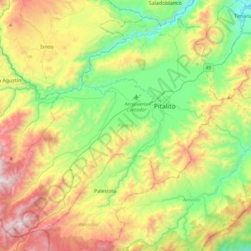
Name: Pitalito topographic map, elevation, terrain.
Location: Pitalito, Sur, Huila, RAP (Especial) Central, 417030, Colombia (1.65724 -76.32189 1.97668 -75.96183)
Average elevation: 5,364 ft
Minimum elevation: 3,179 ft
Maximum elevation: 9,062 ft
Make a donation
Gear up for your next adventure:
As an Amazon Associate, this site earns from qualifying purchases at no extra cost to you.