Geolocate

Brookings topographic map

Click on the map to display elevation.

About this map

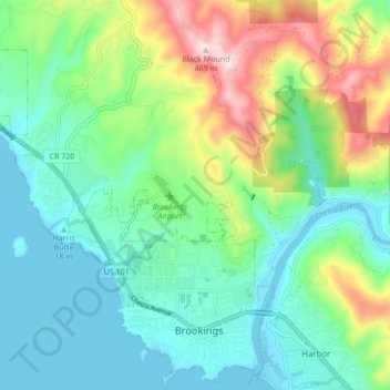
Name: Brookings topographic map, elevation, terrain.

Location: Brookings, Curry County, Oregon, 97415, United States (42.04251 -124.34477 42.10572 -124.26669)

Average elevation: 430 ft

Minimum elevation: -7 ft

Maximum elevation: 1,519 ft

Curry County trails, hiking, mountain biking, running and outdoor activities

Other topographic maps

Click on a map to view its topography, its elevation and its terrain.

Winchuck

United States > Oregon > Curry County

Average elevation: 302 ft

Langlois

United States > Oregon > Curry County

Average elevation: 190 ft

Cape Blanco

United States > Oregon > Curry County

Average elevation: 26 ft

Big Bend

United States > Oregon > Curry County

Average elevation: 577 ft

Langlois

United States > Oregon > Curry County

Average elevation: 190 ft

Cape Blanco

United States > Oregon > Curry County

Average elevation: 26 ft

Gear up for your next adventure:

📶Satellite Messenger - Communication device off‑grid
🎒Trekking Poles - Sturdy poles for balance and stability on rough terrain
👟Trail Running Shoes - Lightweight shoes for trail runners
🧣Hiking Neck Gaiter - Multi‑use neck protection for outdoor weather
🪵Folding Camp Saw - Compact saw for wood and campsite work

As an Amazon Associate, this site earns from qualifying purchases at no extra cost to you.