
Thank you for supporting this site ❤️
Make a donation
Make a donation
Gear up for your next adventure:
As an Amazon Associate, this site earns from qualifying purchases at no extra cost to you.
Cacalomacan topographic map
Click on the map to display elevation.
Thank you for supporting this site ❤️
Make a donation
Make a donation
Gear up for your next adventure:
As an Amazon Associate, this site earns from qualifying purchases at no extra cost to you.
About this map
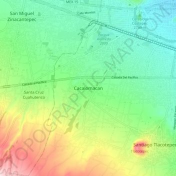
Name: Cacalomacan topographic map, elevation, terrain.
Location: Cacalomacan, Toluca, State of Mexico, 50265, Mexico (19.21182 -99.74302 19.29182 -99.66302)
Average elevation: 9,154 ft
Minimum elevation: 8,753 ft
Maximum elevation: 9,974 ft
Thank you for supporting this site ❤️
Make a donation
Make a donation
Gear up for your next adventure:
As an Amazon Associate, this site earns from qualifying purchases at no extra cost to you.