
Chaspuzac topographic map
Interactive map
Click on the map to display elevation.
About this map
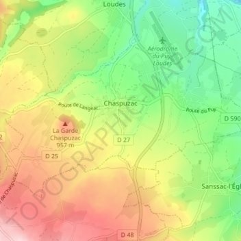
Name: Chaspuzac topographic map, elevation, terrain.
Average elevation: 2,907 ft
Minimum elevation: 2,559 ft
Maximum elevation: 3,323 ft
Other topographic maps
Click on a map to view its topography, its elevation and its terrain.
Fayon
Frankreich > Auvergne-Rhone-Alpen > Haute-Loire > Champclause
Fayon, Champclause, Le Puy-en-Velay, Haute-Loire, Auvergne-Rhone-Alpen, Metropolitanes Frankreich, Frankreich
Average elevation: 3,976 ft
Le Puy-en-Velay
Frankreich > Auvergne-Rhone-Alpen > Haute-Loire
Le Puy-en-Velay, Haute-Loire, Auvergne-Rhone-Alpen, Metropolitanes Frankreich, 43000, Frankreich
Average elevation: 2,418 ft
Pont d'Estroulhas
Frankreich > Auvergne-Rhone-Alpen > Haute-Loire > Le Puy-en-Velay > Pont d'Estroulhas
Pont d'Estroulhas, Le Puy-en-Velay, Haute-Loire, Auvergne-Rhone-Alpen, Metropolitanes Frankreich, 43000, Frankreich
Average elevation: 2,283 ft