
مستونگ topographic map
Interactive map
Click on the map to display elevation.
About this map
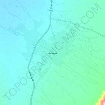
Name: مستونگ topographic map, elevation, terrain.
Location: مستونگ, Baloutchistan, 88200, Pakistan (29.76004 66.81004 29.84004 66.89004)
Average elevation: 5,548 ft
Minimum elevation: 5,299 ft
Maximum elevation: 7,648 ft
Other topographic maps
Click on a map to view its topography, its elevation and its terrain.
خضدار
خضدار, District de Khuzdar, Baloutchistan, 89100, Pakistan
Average elevation: 4,649 ft
Lasbela District
Lasbela District, ضلع لسبیلہ, Baloutchistan, Pakistan
Average elevation: 804 ft
تفتان
Pakistan > Baloutchistan > تفتان
تفتان, ضلع چاغی, Baloutchistan, Pakistan
Average elevation: 2,664 ft
Zhob
Pakistan > Baloutchistan > Zhob
Zhob, Zhob District, Baloutchistan, 85200, Pakistan
Average elevation: 5,144 ft
Kech
Pakistan > Baloutchistan > Turbat
Kech, Turbat, ضلع گوادر / Kech, Baloutchistan, 92600, Pakistan
Average elevation: 1,841 ft