
Nottuln topographic map
Interactive map
Click on the map to display elevation.
About this map
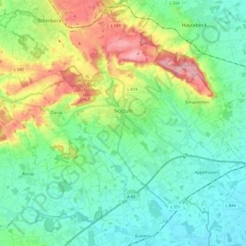
Name: Nottuln topographic map, elevation, terrain.
Location: Nottuln, Kreis Coesfeld, Nordrhein-Westfalen, 48301, Deutschland (51.87692 7.25410 51.97061 7.46244)
Average elevation: 322 ft
Minimum elevation: 197 ft
Maximum elevation: 630 ft
Other topographic maps
Click on a map to view its topography, its elevation and its terrain.
Seppenrade
Deutschland > Nordrhein-Westfalen > Kreis Coesfeld > Lüdinghausen
Seppenrade, Lüdinghausen, Kreis Coesfeld, Nordrhein-Westfalen, 59348, Deutschland
Average elevation: 262 ft
Billerbeck
Deutschland > Nordrhein-Westfalen > Kreis Coesfeld
Billerbeck, Kreis Coesfeld, Nordrhein-Westfalen, 48727, Deutschland
Average elevation: 371 ft
Coesfeld
Deutschland > Nordrhein-Westfalen > Kreis Coesfeld
Coesfeld, Kreis Coesfeld, Nordrhein-Westfalen, 48653, Deutschland
Average elevation: 279 ft