
Serengetti Park topographic map
Interactive map
Click on the map to display elevation.
About this map
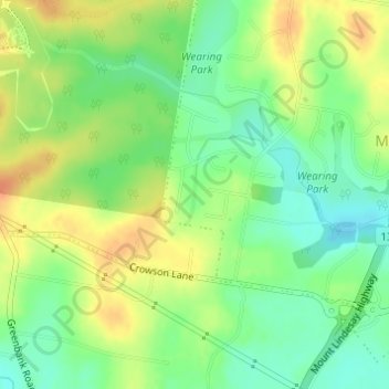
Name: Serengetti Park topographic map, elevation, terrain.
Average elevation: 121 ft
Minimum elevation: 56 ft
Maximum elevation: 194 ft
Other topographic maps
Click on a map to view its topography, its elevation and its terrain.
Edens Landing
Australia > Queensland > Logan City
Edens Landing, Logan City, Queensland, Australia
Average elevation: 89 ft
Thornside Park
Australia > Queensland > Logan City
Thornside Park, Eagleby, Logan City, Queensland, Australia
Average elevation: 39 ft