
Hoyerswerda - Wojerecy topographic map
Interactive map
Click on the map to display elevation.
About this map
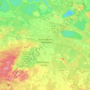
Name: Hoyerswerda - Wojerecy topographic map, elevation, terrain.
Average elevation: 410 ft
Minimum elevation: 272 ft
Maximum elevation: 633 ft
Other topographic maps
Click on a map to view its topography, its elevation and its terrain.
Radeberg
Germany > Saxony > Bautzen - Budyšin
Radeberg, Bautzen - Budyšin, Saxony, 01454, Germany
Average elevation: 843 ft