
Niderrüti topographic map
Interactive map
Click on the map to display elevation.
About this map
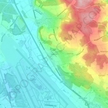
Name: Niderrüti topographic map, elevation, terrain.
Location: Niderrüti, Winkel, Bezirk Bülach, Zürich, 8185, Schweiz (47.46017 8.53686 47.50017 8.57686)
Average elevation: 1,542 ft
Minimum elevation: 1,348 ft
Maximum elevation: 1,952 ft
Other topographic maps
Click on a map to view its topography, its elevation and its terrain.
Winkel
Schweiz > Zürich > Bezirk Bülach > Winkel
Winkel, Bezirk Bülach, Zürich, 8185, Schweiz
Average elevation: 1,555 ft