
Thank you for supporting this site ❤️
Make a donation
Make a donation
Gear up for your next adventure:
As an Amazon Associate, this site earns from qualifying purchases at no extra cost to you.
Georgenborn topographic map
Click on the map to display elevation.
Thank you for supporting this site ❤️
Make a donation
Make a donation
Gear up for your next adventure:
As an Amazon Associate, this site earns from qualifying purchases at no extra cost to you.
About this map
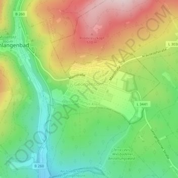
Name: Georgenborn topographic map, elevation, terrain.
Location: Georgenborn, Schlangenbad, Rheingau-Taunus-Kreis, Hesse, Germany (50.08114 8.11023 50.09198 8.13780)
Average elevation: 1,152 ft
Minimum elevation: 666 ft
Maximum elevation: 1,788 ft
Thank you for supporting this site ❤️
Make a donation
Make a donation
Gear up for your next adventure:
As an Amazon Associate, this site earns from qualifying purchases at no extra cost to you.