
Povolide topographic map
Interactive map
Click on the map to display elevation.
About this map
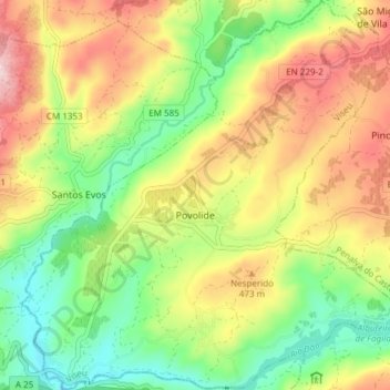
Name: Povolide topographic map, elevation, terrain.
Location: Povolide, Viseu, Portugal (40.63341 -7.83301 40.69066 -7.75898)
Average elevation: 1,335 ft
Minimum elevation: 896 ft
Maximum elevation: 1,886 ft
Other topographic maps
Click on a map to view its topography, its elevation and its terrain.
Lages de Ranhados
Portugal > Viseu > Viseu > Ranhados
Lages de Ranhados, Ranhados, Viseu, 3500-456, Portugal
Average elevation: 1,493 ft
Moure de Madalena
Portugal > Viseu > Viseu > Campo
Moure de Madalena, Campo, Viseu, 3515-160, Portugal
Average elevation: 1,729 ft