
Make a donation
Gear up for your next adventure:
As an Amazon Associate, this site earns from qualifying purchases at no extra cost to you.
Dalton topographic map
Click on the map to display elevation.
Make a donation
Gear up for your next adventure:
As an Amazon Associate, this site earns from qualifying purchases at no extra cost to you.
About this map
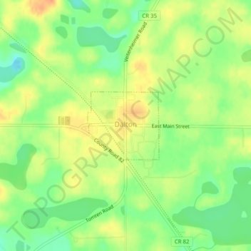
Name: Dalton topographic map, elevation, terrain.
Location: Dalton, Otter Tail County, Minnesota, United States (46.17003 -95.92153 46.17734 -95.91041)
Average elevation: 1,339 ft
Minimum elevation: 1,270 ft
Maximum elevation: 1,401 ft
Otter Tail County trails, hiking, mountain biking, running and outdoor activities
Make a donation
Gear up for your next adventure:
As an Amazon Associate, this site earns from qualifying purchases at no extra cost to you.
Other topographic maps
Click on a map to view its topography, its elevation and its terrain.
Fergus Falls
United States > Minnesota > Otter Tail County > Fergus Falls > Fergus Falls
Average elevation: 1,230 ft
West Battle Lake
United States > Minnesota > Otter Tail County > Battle Lake
Average elevation: 1,352 ft
Mills Manor Mobile Home Park
United States > Minnesota > Otter Tail County > New York Mills > Mills Manor Mobile Home Park
Average elevation: 1,407 ft
Make a donation
Gear up for your next adventure:
As an Amazon Associate, this site earns from qualifying purchases at no extra cost to you.