
Mae Sai district topographic map
Interactive map
Click on the map to display elevation.
About this map
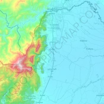
Name: Mae Sai district topographic map, elevation, terrain.
Average elevation: 1,722 ft
Minimum elevation: 1,198 ft
Maximum elevation: 4,829 ft
Other topographic maps
Click on a map to view its topography, its elevation and its terrain.
Chiang Rai
Thailand > Chiang Rai Province > Chiang Rai
Chiang Rai, Tha Sai, Chiang Rai Province, 57000, Thailand
Average elevation: 1,552 ft
Ban Lao
Thailand > Chiang Rai Province > Ban Lao
Ban Lao, Chiang Rai Province, Thailand
Average elevation: 1,322 ft
Ban Muang Chum
Thailand > Chiang Rai Province > Ban Muang Chum
Ban Muang Chum, Chiang Rai Province, Thailand
Average elevation: 1,316 ft
Ban Wiang Chai
Thailand > Chiang Rai Province
Ban Wiang Chai, Wiang Nuea, Chiang Rai Province, Thailand
Average elevation: 1,280 ft
Lam Mueang Sai
Thailand > Chiang Rai Province > Chiang Rai
Lam Mueang Sai, Chiang Rai, Chiang Rai Province, 57000, Thailand
Average elevation: 1,319 ft