
Sumaré topographic map
Click on the map to display elevation.
Sumaré
Sumaré is a city in the State of São Paulo, Brazil. It is part of the Metropolitan Region of Campinas. The population is 286,211 (2020 est.) in an area of 153.47 km². The elevation is 583 m. Sumaré was founded in 1868, after being upgraded to a city. Its old name was Rebouças. There is a Honda plant located there for Honda Brazil.
About this map
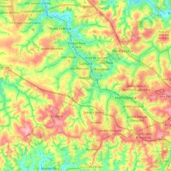
Name: Sumaré topographic map, elevation, terrain.
Average elevation: 1,952 ft
Minimum elevation: 1,745 ft
Maximum elevation: 2,182 ft
Other topographic maps
Click on a map to view its topography, its elevation and its terrain.
João Aranha
Brazil > São Paulo > Região Metropolitana de Campinas > Paulínia
Average elevation: 1,913 ft