
龙廷镇 topographic map
Interactive map
Click on the map to display elevation.
About this map
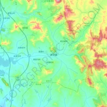
Name: 龙廷镇 topographic map, elevation, terrain.
Location: 龙廷镇, 新泰市, 泰安市, 山东省, 271200, 中国 (35.86692 117.79840 35.98396 117.99666)
Average elevation: 1,115 ft
Minimum elevation: 699 ft
Maximum elevation: 2,339 ft
Other topographic maps
Click on a map to view its topography, its elevation and its terrain.