
Stearns topographic map
Interactive map
Click on the map to display elevation.
About this map
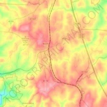
Name: Stearns topographic map, elevation, terrain.
Location: Stearns, McCreary County, Kentucky, United States (36.67351 -84.50036 36.71649 -84.45583)
Average elevation: 1,286 ft
Minimum elevation: 1,001 ft
Maximum elevation: 1,434 ft
Other topographic maps
Click on a map to view its topography, its elevation and its terrain.
Yamacraw
United States > Kentucky > McCreary County
Yamacraw, McCreary County, Kentucky, 42647, United States
Average elevation: 1,033 ft
Flat Rock
United States > Kentucky > McCreary County
Flat Rock, McCreary County, Kentucky, 42653, United States
Average elevation: 1,227 ft
Bell Farm
United States > Kentucky > McCreary County
Bell Farm, McCreary County, Kentucky, United States
Average elevation: 1,211 ft
Strunk
United States > Kentucky > McCreary County > Strunk
Strunk, McCreary County, Kentucky, 42649, United States
Average elevation: 1,345 ft
Pine Knot
United States > Kentucky > McCreary County
Pine Knot, McCreary County, Kentucky, United States
Average elevation: 1,309 ft
Whitley City
United States > Kentucky > McCreary County
Whitley City, McCreary County, Kentucky, 42563, United States
Average elevation: 1,280 ft