
Thank you for supporting this site ❤️
Make a donation
Make a donation
Gear up for your next adventure:
As an Amazon Associate, this site earns from qualifying purchases at no extra cost to you.
Strunk topographic map
Click on the map to display elevation.
Thank you for supporting this site ❤️
Make a donation
Make a donation
Gear up for your next adventure:
As an Amazon Associate, this site earns from qualifying purchases at no extra cost to you.
About this map
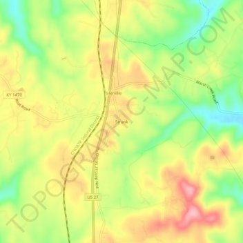
Name: Strunk topographic map, elevation, terrain.
Location: Strunk, McCreary County, Kentucky, 42649, United States (36.60202 -84.45355 36.64202 -84.41355)
Average elevation: 1,345 ft
Minimum elevation: 1,096 ft
Maximum elevation: 1,581 ft
McCreary County trails, hiking, mountain biking, running and outdoor activities
Thank you for supporting this site ❤️
Make a donation
Make a donation
Gear up for your next adventure:
As an Amazon Associate, this site earns from qualifying purchases at no extra cost to you.