
Make a donation
Gear up for your next adventure:
As an Amazon Associate, this site earns from qualifying purchases at no extra cost to you.
Boswell topographic map
Click on the map to display elevation.
Make a donation
Gear up for your next adventure:
As an Amazon Associate, this site earns from qualifying purchases at no extra cost to you.
About this map
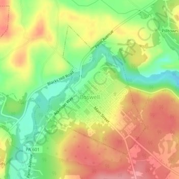
Name: Boswell topographic map, elevation, terrain.
Location: Boswell, Somerset County, Pennsylvania, United States (40.15283 -79.03774 40.17235 -79.01786)
Average elevation: 1,913 ft
Minimum elevation: 1,749 ft
Maximum elevation: 2,060 ft
Somerset County trails, hiking, mountain biking, running and outdoor activities
Make a donation
Gear up for your next adventure:
As an Amazon Associate, this site earns from qualifying purchases at no extra cost to you.
Other topographic maps
Click on a map to view its topography, its elevation and its terrain.
Pike's Peak
United States > Pennsylvania > Somerset County > Jenner Township
Average elevation: 2,684 ft
Hollsopple
United States > Pennsylvania > Somerset County > Conemaugh Township
Average elevation: 1,788 ft
Kantner
United States > Pennsylvania > Somerset County > Quemahoning Township
Average elevation: 1,995 ft
Ralphton
United States > Pennsylvania > Somerset County > Quemahoning Township > Ralphton
Average elevation: 2,087 ft
Make a donation
Gear up for your next adventure:
As an Amazon Associate, this site earns from qualifying purchases at no extra cost to you.
Listie
United States > Pennsylvania > Somerset County > Somerset Township > Listie
Average elevation: 2,238 ft
Boynton
United States > Pennsylvania > Somerset County > Elk Lick Township > Boynton
Average elevation: 2,152 ft
Bearwallow Mountain
United States > Pennsylvania > Somerset County > Fairhope Township
Average elevation: 2,165 ft