
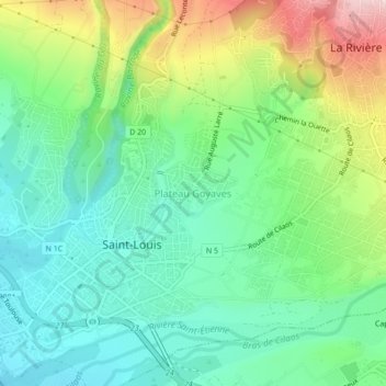
Plateau Goyaves topographic map
Interactive map
Click on the map to display elevation.
About this map
Name: Plateau Goyaves topographic map, elevation, terrain.
Average elevation: 331 ft
Minimum elevation: 0 ft
Maximum elevation: 1,033 ft
Other topographic maps
Click on a map to view its topography, its elevation and its terrain.
Les Makes
France > La Réunion > Saint-Louis
Les Makes, Saint-Louis, Saint-Pierre, La Réunion, France
Average elevation: 3,238 ft
Roche Maigre
France > La Réunion > Saint-Louis > Plateau Goyaves
Roche Maigre, Plateau Goyaves, Saint-Louis, Saint-Pierre, La Réunion, 97450, France
Average elevation: 486 ft
Rivière Saint-Étienne
France > La Réunion > Saint-Louis
Rivière Saint-Étienne, Saint-Louis, Saint-Pierre, La Réunion, 97450, France
Average elevation: 39 ft
Ravine du Maniron
France > La Réunion > Saint-Louis
Ravine du Maniron, Saint-Louis, Saint-Pierre, La Réunion, 97450, France
Average elevation: 20 ft
Bellevue
France > La Réunion > Saint-Louis > Bellevue
Bellevue, Saint-Louis, Saint-Pierre, La Réunion, 97450, France
Average elevation: 994 ft
Petit-Serré
France > La Réunion > Saint-Louis
Petit-Serré, Saint-Louis, Saint-Pierre, La Réunion, 97421, France
Average elevation: 2,592 ft