
Oostakker topographic map
Interactive map
Click on the map to display elevation.
About this map
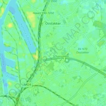
Name: Oostakker topographic map, elevation, terrain.
Location: Oostakker, Gand, Flandre orientale, 9041, Belgique (51.06972 3.75223 51.10875 3.81088)
Average elevation: 23 ft
Minimum elevation: -26 ft
Maximum elevation: 56 ft
Other topographic maps
Click on a map to view its topography, its elevation and its terrain.
Swynaerde
Belgique > Flandre orientale > Gand > Gand
Swynaerde, Gand, Flandre orientale, Flandre, 9052, Belgique
Average elevation: 30 ft
Gand
Belgique > Flandre orientale > Gand > Gand
Gand, Flandre orientale, Flandre, 24-32, Belgique
Average elevation: 39 ft