Geolocate

Tlogomas topographic map

Click on the map to display elevation.

About this map

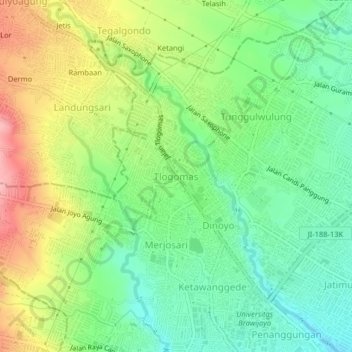
Name: Tlogomas topographic map, elevation, terrain.

Location: Tlogomas, Malang, Kota Malang, East Java, Java, 65144, Indonesia (-7.95564 112.58483 -7.91564 112.62483)

Average elevation: 1,726 ft

Minimum elevation: 1,545 ft

Maximum elevation: 2,001 ft

Other topographic maps

Click on a map to view its topography, its elevation and its terrain.

Bumiayu

Indonesia > East Java > Kota Malang > Malang

Average elevation: 1,394 ft

Lesanpuro

Indonesia > East Java > Kota Malang > Malang

Average elevation: 1,601 ft

Bandungrejosari

Indonesia > East Java > Kota Malang > Malang

Average elevation: 1,407 ft

Alun-Alun Malang

Indonesia > East Java > Kota Malang > Malang > Kiduldalem

Average elevation: 1,453 ft

Bunulrejo

Indonesia > East Java > Kota Malang > Malang

Average elevation: 1,480 ft

Taman Merbabu

Indonesia > East Java > Kota Malang > Malang > Oro Oro Dowo

Average elevation: 1,519 ft

Sungai Metro

Indonesia > East Java > Kota Malang > Malang > Sukun

Average elevation: 1,407 ft

Gear up for your next adventure:

🧭Pro Hiking Compasses - High-accuracy liquid-filled compasses for topographic orientation
🎒Waterproof Dry Bags - Keep your electronics and maps dry inside your pack
GPS Sports Watch - GPS watch for running, hiking and training
🚑Emergency Bivvies - Heat-reflective sleeping bags for survival situations
🏕️Tent Footprint - Protect your tent base from wear

As an Amazon Associate, this site earns from qualifying purchases at no extra cost to you.