Geolocate

Pottammal topographic map

Click on the map to display elevation.

About this map

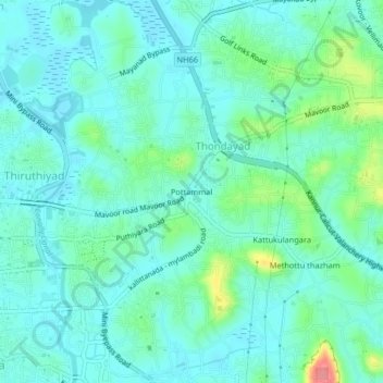
Name: Pottammal topographic map, elevation, terrain.

Location: Pottammal, Thondayad, Kozhikode, Kerala, 670016, India (11.24019 75.78832 11.28019 75.82832)

Average elevation: 66 ft

Minimum elevation: 7 ft

Maximum elevation: 282 ft

Other topographic maps

Click on a map to view its topography, its elevation and its terrain.

Kottooli

India > Kerala > Kozhikode > Thondayad > Pottammal

Average elevation: 59 ft

Nellikode

India > Kerala > Kozhikode > Thondayad > Methottu thazham

Average elevation: 85 ft

Gear up for your next adventure:

🪶Compact Camp Shovel - Folding shovel for campsite tasks
🔭Compact Binoculars - HD vision for scouting terrain and identifying distant landmarks
📷Action Cameras - Rugged cameras to document your journeys across rugged terrain
🪶Thermal Camp Blanket - Extra warmth for cold nights
📱Heavy-Duty Phone Cases - Drop-proof and waterproof protection for outdoor navigation

As an Amazon Associate, this site earns from qualifying purchases at no extra cost to you.