
Gemeinde Kirchberg in Tirol topographic map
Interactive map
Click on the map to display elevation.
About this map
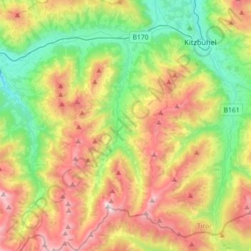
Name: Gemeinde Kirchberg in Tirol topographic map, elevation, terrain.
Average elevation: 4,364 ft
Minimum elevation: 2,188 ft
Maximum elevation: 7,641 ft
Other topographic maps
Click on a map to view its topography, its elevation and its terrain.
Marktgemeinde Fieberbrunn
Austria > Tyrol > Bezirk Kitzbühel > Marktgemeinde Fieberbrunn
Marktgemeinde Fieberbrunn, Bezirk Kitzbühel, Tyrol, 6391, Austria
Average elevation: 4,085 ft