
Palis topographic map
Interactive map
Click on the map to display elevation.
About this map
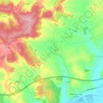
Name: Palis topographic map, elevation, terrain.
Average elevation: 617 ft
Minimum elevation: 390 ft
Maximum elevation: 896 ft
Other topographic maps
Click on a map to view its topography, its elevation and its terrain.
Villemaur-sur-Vanne
France > Grand Est > Aube > Aix-Villemaur-Pâlis
Villemaur-sur-Vanne, Aix-Villemaur-Pâlis, Troyes, Aube, Grand Est, France métropolitaine, 10190, France
Average elevation: 531 ft
La Bouillant
France > Grand Est > Aube > Aix-Villemaur-Pâlis > Aix-en-Othe
La Bouillant, Aix-en-Othe, Aix-Villemaur-Pâlis, Troyes, Aube, Grand Est, France métropolitaine, 10160, France
Average elevation: 676 ft
Aix-en-Othe
France > Grand Est > Aube > Aix-Villemaur-Pâlis
Aix-en-Othe, Aix-Villemaur-Pâlis, Troyes, Aube, Grand Est, France métropolitaine, 10160, France
Average elevation: 666 ft