
Mezio topographic map
Interactive map
Click on the map to display elevation.
About this map
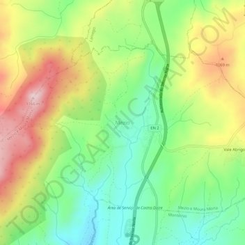
Name: Mezio topographic map, elevation, terrain.
Location: Mezio, Castro Daire, Viseu, Portugal (40.96416 -7.91164 41.00416 -7.87164)
Average elevation: 3,179 ft
Minimum elevation: 2,733 ft
Maximum elevation: 3,789 ft
Other topographic maps
Click on a map to view its topography, its elevation and its terrain.
Ermida
Portugal > Viseu > Castro Daire
Ermida, Picão e Ermida, Castro Daire, Viseu, Portugal
Average elevation: 1,818 ft
Cêtos
Portugal > Viseu > Castro Daire > Pinheiro
Cêtos, Pinheiro, Castro Daire, Viseu, Portugal
Average elevation: 2,418 ft
Monteiras
Portugal > Viseu > Castro Daire
Monteiras, Castro Daire, Viseu, Portugal
Average elevation: 2,946 ft
Folgosa
Portugal > Viseu > Castro Daire
Folgosa, Castro Daire, Viseu, 3600-143, Portugal
Average elevation: 1,955 ft
Gosende
Portugal > Viseu > Castro Daire
Gosende, Castro Daire, Viseu, Portugal
Average elevation: 3,317 ft
Almofala
Portugal > Viseu > Castro Daire
Almofala, Castro Daire, Viseu, 3600-011, Portugal
Average elevation: 2,949 ft